Hiking trails are an excellent way of getting to know the natural and cultural heritage of Sintra municipality.
Characteristics of marked hiking trails in the Sintra-Cascais Natural Park:
Short Route 1 - Santa Maria
Type of route: Circular, approx.1,9 Km
Reference points: Fonte da Sabuga, Igreja de Santa Maria and Parque da Liberdade
Starting point: Palácio Nacional de Sintra - GPS: 38.797052, -9.390642
This trail starts at the Largo Rainha Dª Amélia (historical centre), by the Palácio Nacional de Sintra. It is a short trail, easily accessible, which aims to show a little of the historical centre of Sintra Town and has as its main objective passing by the Santa Maria Church.
The route starts at the Rua das Padarias, located in front of the Palácio Nacional de Sintra, the Sintra National Palace. Among relevant points of interest throughout this Route are the viewpoint Miradouro da Ferraria, Fonte da Sabuga, (a fountain of medieval origins, rebuilt in the late 18th century), Igreja de Santa Maria (a 12th century church) and Parque da Liberdade (Freedom Park) with its exuberant exotic flora.
Igreja de Santa Maria
Built by Portugal’s first king, D. Afonso Henriques, in the 12th century, the church has undergone several alterations throughout time, in particular towards the end of the 13th century, early 14th century and after the earthquake of 1755. Today it is a Gothic-Romanesque building with three naves, with ogival arches and finely worked capitals - one of the few traces of the Middle Ages still remaining.
Total descent: 141m

Short Route 2/3 - Castelo dos Mouros and Palácio Nacional da Pena
Type of route: Circular, approx.4,5 Km
Reference points: Fonte da Sabuga, Igreja de Santa Maria, S. Pedro de Penaferrim, Palácio Nacional da Pena and Castelo dos Mouros
Starting point: Palácio Nacional de Sintra - GPS: 38.797648, -9.390783
This trail starts out at the Largo Rainha Dª Amélia (historical centre), by the Palácio Nacional de Sintra. It combines two previous routes (Pena and Castelo) and its purpose is to reach these two monuments, the Pena Palace and the Moorish Castle, using hiking trails. The route begins at the Rua das Padarias, a street across from the Largo do Palácio Nacional de Sintra.
Highlights of the route are the viewpoint Miradouro da Ferraria, Fonte da Sabuga (a fountain of medieval origins rebuilt in the late 18th century), Igreja de Santa Maria (a 12th century church) , the Casa do Adro (the house where Danish poet and writer Hans Christian Andersen lived in 1866), Convento da Santíssima Trindade (a convent founded in the late 14th century), Capela de São Pedro de Penaferrim (a 12th century chapel) and Álea Ferreira de Castro, where the writer Ferreira de Castro (1898-1974)is buried. At the highest point of the trail the Pena Palace and the Moorish Castle can be visited.
Palácio Nacional da Pena
“Today is the happiest day of my life. I know Italy, Sicily, Greece and Egypt, and I have never, ever seen anything to match the Pena. It is the most beautiful thing I have ever seen. This is the true garden of Klingsor - and there, high up above, is the Castle of the Holy Grail”.
Richard Strauss
Total descent: 140m
Short Route 4 - Seteais
Type of route: Circular, approx.3,5 Km
Reference points: Torre do Relógio, Igreja de São Martinho, Quinta da Regaleira, Hotel Palácio de Seteais, Rampa da Pena and Fonte da Pipa
Starting point: Palácio Nacional de Sintra - GPS: 38.797648, -9.390783
This trail starts at the Largo Rainha Dª Amélia (historical centre) by the Palácio Nacional de Sintra. Although not very long, this trail includes a steep slope. Its main objective is to walk through the historical centre and to pass by the Palácio de Seteais.
The circular route begins at the Praça da República, continues towards the Tourist Office, then passes by the Igreja de S. Martinho (a church from the second half of the 12th century), Fonte dos Pisões ( a fountain from the first half of the 20th century), Quinta da Regaleira, Hotel Palácio de Seteais, ( Seteais Palace dating back to the second half of the 12th century is now a Hotel) and Fonte da Pipa fountain.
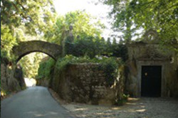
Palácio de Seteais
The Seteais Palace, built in the 18th century, is considered a national heritage building. Of neo-classical architecture, it belongs to a group of palaces that were restored by the Portuguese bourgeoisie of the time. According to legend, the name derives from the tradition that says calling out an “ai” from the road this would be echoed, hence the name “sete-ais”, “seven-ais”.
Total descent: 212m
Short Route 5 - Quintas
Type of route: Circular, approx. 2,3 km
Reference points: Torre do Relógio, Igreja de São Martinho, Quinta da Regaleira, Quinta do Relógio, Quinta do Castanheiro, Quinta dos Alfinetes, Quinta D. Amélia and Quinta dos Castanhais
Starting point: Palácio Nacional de Sintra - GPS: 38.797648, -9.390783
This is a short trail that takes you by the most emblematic Quintas - traditional estates and manor or farm houses - of the historical centre, and ends at the Largo do Palácio Nacional de Sintra (Largo Rainha Dª Amélia).
The beginning of this route is similar to PR4, diverging only in front of Quinta da Regaleira, where it follows a trail to the right, passing in front of Quinta do Relógio.
This route has a moderate drop and its purpose is to show, at the edge of the Old Town of Sintra, the main ancestral Quintas. Noteworthy is the Quinta do Castanheiro, which still has a fine specimen of the tree it was named after - the Chestnut tree. The trail returns to the town of Sintra by the Castanhais path.
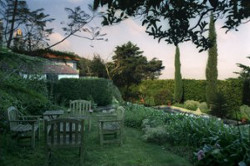
Quinta da Regaleira
This Quinta is one of the most astonishing monuments of the Serra de Sintra. Located at the edge of the historical centre of the town of Sintra, it was built between 1904 and 1910, during the final period of the monarchy.
The romantic domains once belonging to the Viscountess of Regaleira were bought and extended by António Augusto Carvalho Monteiro (1848-1920) for the founding of his place of choice. A man of prodigious wealth, Carvalho Monteiro added to his unique architectural and landscaping project the creative genius of Italian architect and set-designer Luigi Manini (1848-1936).
Total descent: 128m
Short Route 6 - Rio da Mula
Type of route: Circular, approx.11,3 km
Reference points: Barragem Rio da Mula, Convento dos Capuchos, Memorial dos Soldados and Pedra Amarela
Starting point: Barragem Rio da Mula - GPS: 38.763704, -9.422198
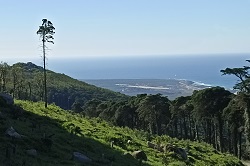
Starting at the Barragem do Rio da Mula, a river dam, this trail has a first ascending phase, which runs across the southern slope of the mountain through the forest.
This being a mountain trail, you may, mostly in winter, find a varied and more unstable footing, surrounded by extensive vegetation, exotic and exuberant, including even species of flora prior to the glacial era.
With a sharp gradient and of average length, this is a trail of unparalleled beauty that leads the hiker to some secluded spots of this wonderful Serra de Sintra.
The trail spreads mostly over the southern side of the mountain, more protected from Sintra’s characteristic North winds, providing a welcoming and sheltered path in an environment of total integration with Nature, in harmony with the local flora and fauna.
Barragem do Rio da Mula
This is a dam located at the border area between Sintra and Cascais, receiving water from the southern mountain slope watershed. The Rio da Mula, or Mule River - also known as ribeira das Vinhas (Vineyard stream), ribeira dos Marmeleiros (Quince tree stream), or rio Doce (Sweet river) according to the where it passes - flows from its source in the serra de Sintra to its mouth in the ocean in Cascais.
Total descent: 664m
Short Route 7 - Cabo da Roca
Type of route: Circular, approx.13,2 km
Reference points: Ulgueira, Praia da Adraga, Praia Grande do Rodízio /dinosaur footprints and Almoçageme.
Starting point: Cabo da Roca - GPS: 38.781167, -9.497417
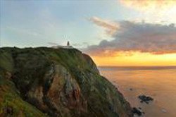
Cabo da Roca is the starting point for this trail. The route covers the cliffs on the coastal area, passing by spectacular viewpoints such as Pedra de Alvidrar and Buraco do Fojo, on the southern slope of Praia da Adraga. Not being a trail with steep drops, it includes passing through Praia da Adraga and Praia Grande. These two beaches are important and famous in Sintra due to, for example, the dinosaur footprint tracks on the cliff south of Praia Grande. On the way back, the route runs through the villages of Almoçageme and Ulgueira, two spots quite representative of the typical “saloia” peasant atmosphere.
Cabo da Roca
Cabo da Roca “Where the earth ends and the sea begins” (in Os Lusíadas, Canto III) is the westernmost point of continental Portugal, as well as of continental Europe.
Total descent: 497m

Short Route 8 - Vinho de Colares
Type of route: Circular, approx. 15,5 km
Reference points: Adega Regional de Colares, Pinhal da Nazaré, Vinhas do Vinho de Colares, Fontanelas and Janas
Starting point: Adega Regional de Colares- GPS: 38.805959, -9.450007
This route begins in the rural area by the Adega Regional de Colares, the Colares Regional Winery. The trail, for the most part flat, unfolds between the Pine forest area and the Atlantic Coast, stretches to the north of the Winery and passes by the Adega Visconde Salreu, reaching its most distant point at the villages of Fontanelas and Gouveia (a village where street names are in verse). This route leads you to the discover y of an area of Sintra with all its peculiarities: the “saloia”peasant region and the ancestral vineyards. The original planting of these vines is ancient and unique, with its Ramisco grape variety.
Adega Regional de Colares
The Adega Regional de Colares, Colares Regional Winery, founded in 1931, is Portugal’s oldest Winery Cooperative, which at present incorporates the majority of the producers of the Demarcated Region of Colares, playing an important social role in the Sintra area.
The building is impressive, the interior is stunning, owing to its size and the number of casks it holds, and is the area for storage and ageing of the wine, in wood for excellence, of this Demarcated Region.
Total descent: 280m
Short Route 9 - Rota das Aldeias
Type of route: Circular, approx. 13,5 km
Reference Points: São João das Lampas, Ponte Romana da Catribana, Assafora and Catribana
Starting point: Largo de S.joão das Lampas - GPS: 38.874315,-9.398434
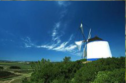
This Village Route, with start and finish at the Largo do Coreto in São João das Lampas, runs through an interesting agricultural area of Sintra. Throughout this beautiful route we can appreciate a mosaic of pasture land and small farmed plots, separated by dry stone walling and hedges, sprinkled with Pine forests. We are in the heart of the most typical of «saloia» countryside regions, where local ancestral customs are still kept alive. Rural roads, some of Roman origin, protected by traditional stone walls between streams, fountains and windmills, are some of the curiosities to be found here. Of particular note, for its age and architecture, is the Roman Bridge at Catribana, a recently restored monument. Many of these routes were used in ancient times for travelling between sites on foot or with animal traction vehicles, to trade horticultural products at fairs and markets in the region.
Igreja Matriz de São João Batista
The São João Batista Church in São João das Lampas is an exquisite temple of late medieval architecture. Although the first known documents date back to the 15th century it’s highly likely that the first existing structure could have appeared as early as the13th or 14th centuries. The first great intervention, which took place during the reign of D. Manuel I, is responsible for the magnificent entrance in “manuelino” style, part of the main facade of this church.
The church and churchyard are classified as a Monument of Public Interest.
Total descent: 273m
Short Route 10 - Peninha
Type of route: Circular, approx. 5,9 km
Reference Points: Ermida de Nossa Senhora da Peninha, Ermida de São Saturnino, Adrenunes and Pedras Irmãs
Starting point: Largo da Peninha - GPS: 38.769215, -9.458948
The route begins by the parking area giving access to Peninha.
This trail runs throughout the Sintra Mountain and takes you to an area moulded by winds and the ancestral use for agriculture and grazing.
One can enjoy the view of a vast coastal landscape, from Cabo Espichel all the way to the Berlengas islands.
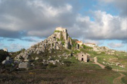
At the top of a chaotic pile of great, rounded boulders, often shrouded by fog, is built the Chapel of Nossa Senhora da Peninha. This chaos of blocks, now exposed, was sculpted by erosion of the syenite rock of the magmatic core of the Sintra Mountain.
One can also find paths where the sun barely penetrates and the density of bush vegetation is immense, evidencing a great resource of water.
It’s also possible to visit Adrenunes where the arrangement of the rocks resembles a Megalithic dolmen.
Capela de Nossa Senhora da Penha
The chapel of Nossa Senhora da Penha (later Peninha) was built thanks to popular devotion, during the reign of D. João III (1502-1557). Legend dating back to the 16th century, has it that Our Lady appeared to a mute shepherdess, a pauper from Almoinhas Velhas. From then on, the site was profoundly worshipped by the local population.
Total descent: 252 m
Short Route 11 - Capuchos
Type of route: Circular, approx. 4, 9 km
Reference points: Convento dos Capuchos, Memorial dos Soldados, Tholos do Monge and Pedra Amarela
Starting point: Largo dos Capuchos - GPS: 38.784314, -9.437018
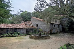
The trail begins at the Convento dos Capuchos, one of the most emblematic and unique religious constructions of the region. The convent was founded in 1560 for Franciscan Friars who were known for their way of life in close harmony with nature.
The trail essentially runs across the top of the Sintra Mountain between Cruz Alta and the Peninha. The embracing and inviting environment of Nature makes this trail the delight of any hiker. It passes by viewpoints and special sites, such as the monument raised in memory of the soldiers who lost their lives fighting the great fire in 1966, as well as the «Tholos do Monge», a pre-historic collective grave (2500/1500 BC),which was also used during the Bronze Age(1800/800 BC).
Convento dos Capuchos
This Convent, also known as Convento da Cortiça (The Cork Convent) or Santa Cruz (Holy Cross), unique of its kind, was founded in 1560 by D. Álvaro de Castro, son to the Vice-Roy of India, D. João, who thus honoured his father’s vow. Intimate, of almost non-human scale, with only the essential to the existence of a few hermits, here a philosophy of life that startles us with its remote and placid modesty endures.
Total descent: 343 m
Short Route 12 - Lapiás
Length: 8 Km
Departure Point: Segueteira Park – Maceira GPS: 38.866934, -9.311076
Points of Interest: Segueteira Park, the limestone pavement at Granja dos Serrões, the Mourão River Waterfalls
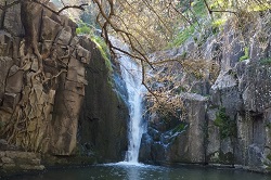
The route starts at Segueteira Park in Maceira next to the public fountain that has a washbasin. First of all, you will walk along an old trail until you reach the limestone pavement in Granja dos Serrões. From there, the trail continues along age-old pathways until you reach the village of Pedra Furada. At the village of Anços after walking down a path with excellent views over the Saloia countryside around Cheleiros and Penedo do Lexim (a Chalcolithic agro-pastoral settlement, which dates from 3000-4000 BC), you will arrive at the famous waterfalls of the Mourão river at the eastern part of Anços.
Total descent: 280m
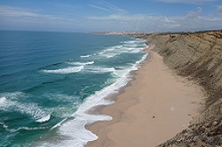
Short Route 13 - Sintra North Beaches
Type of route: Circular route of around 15,5 Km
Points of Interest: São Julião Beach, Vigia Beach, Samarra Beach, Tojeira, the Roman road, Catribana, Cortesia, and Assafora.
Departure point: The car park at São Julião Beach – GPS: 38.9297548,-9.418407;
The route begins in the car park at São Julião beach.
Continuing along the coastline, the trail combines the splendour of Sintra's coast, where you can take in the municipality's most beautiful beaches, with the picturesque countryside of the villages of Assafora and Catribana and its patchwork landscape. The fields are surrounded by dry stone walls very typical in this area, which known as the saloia region.
At certain points during the walk, you will be taken back in time. One such moment is when you come across a Roman bridge like the one at Catribana and part of its Roman road.
Total descent: 634m
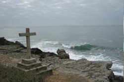
Long Route Trail GR11 - E9 - Caminho do Atlântico
Type of route: Linear, approx. 30 km
Reference points: Ulgueira, Praias da Adraga, Grande, Pequena, Maçãs, Azenhas do Mar, Aguda and Magoito, Odrinhas and Carvalhal
Starting point: Cabo da Roca - GPS: 38.772661, -9.476607
In Sintra, this is part of GR11-E9, the European long distance path that begins in St Petersburg, Russia, and continues along the coast, outlining the European continent territory bathed by the Atlantic Ocean, ending at the Cabo de São Vicente. This part of the trail covers approximately 30 km of the Sintra Region, using traditional foot paths, public accesses and existing public paths, providing a hike in harmony with the coast and with an extraordinarily beautiful landscape.
The trail runs across a range of landscapes, through coastal and mountainous panoramas, rural/agricultural land, at times divided by water streams due to local geological and climatic conditions as well as to the intense, ancestral occupation by mankind. It’s an accessible trail, of low physical demand. The walk doesn’t require any particular hiking techniques
The route
The route begins in the Sintra Council in the village of Ulgueira and finishes in São Miguel de Odrinhas. Covering much of the coast, from Praia da Adraga (Adraga Beach) continuing, always along the coastline, by Praia Grande, Praia Pequena, Praia das Maçãs, Praia da Aguda until it reaches Praia do Magoito. The trail then turns inland, towards the village of Magoito,, heading for São João das Lampas across the countryside. Once inside the rural area it advances through small alleyways, streams, paths and public accesses, flanked by walls until reaching São Miguel de Odrinhas, a village famous for its archeological heritage. Here, you can visit the Museu Arqueológico de São Miguel de Odrinhas(Archeological Museum), hosting the most ancient memories of the Sintra Council, as well as the ruins of a Roman Villa, next to the Medieval Hermitage dedicated to São Miguel.
Within the Sintra Council, São Miguel de Odrinhas will be the northern-most point of the trail, which continues on to Carvalhal and then towards Mafra.
Azenhas do Mar
Azenhas do Mar is a very distinctive village owing to its privileged location, with a splendid landscape and exceptional approach to the Atlantic Ocean that bathes the entire Sintra coast. It stretches along a stream flowing into the ocean and where there were once several «azenhas», (water mills, hence the name). At the base of the surrounding cliffs lie a beach and an ocean pool.
Total descent: 825 m
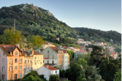
The Caminho do Mar
The Caminho do Mar is a pilgrimage route to Fátima promoted by the Centro Nacional de Cultura. This route is signposted by blue arrows, ending in Fátima. At the same time, the route to Santiago de Compostela is also marked, but with yellow arrows.
The route starts in Cascais and crosses the municipality of Sintra. It consists of quiet roads and paths to provide greater security for pilgrims and other hikers.
RULES OF CONDUCT AND SPECIAL PRECAUTIONS
- Follow and stay only on the way-marked trails
- Respect the local environment; avoid making noise
- Observe fauna from a distance, preferably using binoculars
- Do not leave any litter behind
- No naked flames or any type of fire allowed
USEFUL INFORMATION
SOS emergency -112
SOS Environment -808 200 520
SMS security - 961 010 200
TOURIST OFFICES
Cabo da Roca - 219 280 081
Sintra Town- 219 231 157
Sintra Railway Station-211 932 545
___________________________________________________________________
Right Way-Wrong Way
Turn left-Turn right


